U.S. Customs and Border Protection, originally uploaded by Nathan Gibbs.
Category: borders
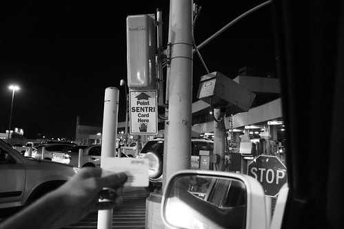
Before approaching the border agent in the SENTRI lane, the RFID card and windshield-mounted sensor show the agent a photo of who to expect. For many, there’s a bit of mystery surrounding the golden ticket we call the SENTRI pass. To get it, you have to submit your weight in paperwork — birth certificate, passport, social security card, drivers license, residence and employment history, vehicle docs (VIN, plates, registration, insurance), proof of residence, employment, pay stubs, bank statements, etc. They run a background check and laser-scan your fingerprints. It’s straight out of Gattaca.
[ view more images of border crossing | slideshow ]
After checking my stats using Google Analytics a few weeks ago, I noticed that Google included Mexico as part of Central America. I thought it odd, because I was taught Mexico was part of North America (as a Google Images search seems to confirm). After all, the NAFTA does include Mexico.
So, I wrote Google Analytics support team with the question. They responded, citing the use of United Nations data:
From: “Analytics Support” <analytics-support@google.com>
Date: June 11, 2007 4:19:59 PM PDT
Subject: Re: [#159418445] Continental ErrorHello Nathan,
Thanks for your inquiry about the maps feature in Google Analytics. We
use Standard Country and Area Codes Classifications (M49) adopted by the
United Nations Statistics Division to determine borders and continental
classifications. To see how the United Nations classifies geographic
regions, visit http://unstats.un.org/unsd/methods/m49/m49regin.htm. We
understand that borders change over time and we make every effort to
reflect the changes periodically within the product. Political borders
within the Google Analytics maps are meant to help our users understand
where their visitors are coming from and should be considered guidelines.
They in no way represent a political opinion or position . . .
The U.N.’s posted methodology also claims these regional definitions are apolitical:
The assignment of countries or areas to specific groupings is for statistical convenience and does not imply any assumption regarding political or other affiliation of countries or territories by the United Nations.

According to the Encyclopedia Britannica, some geologists and physical geographers include parts of Mexico in Central America. Wikipedia’s Central America entry quantifies this area at about 12% of Mexico’s landmass. The same entry says the European Union excludes Mexico and Belize from Central America.
The issue brings home the basic premise that borders and labels can be completely arbitrary. That is, if we removed the labels and borders, we would have land and people living on that land. The borders we have in our world today are 100% political. They establish boundaries where each country considers itself sovereign. When borders move, it’s often a matter of life and death for the locals.
Is it wrong for the U.N. to label Mexico as part of Central America? I don’t know and it doesn’t affect my daily life one way or the other. It does, however, affect the way people and cultures respond to each other. In the U.S., if Mexico is part of “our” North American continent, we might have reason to consider ourselves neighbors. When the U.S. Americans refers to Mexico as “Latin America” it’s an added step of distance, a clarification that those people are something “other” than us. Whether we like it or not, the U.S.A. is the minority in the Americas, and the largest minority group within the country is made up of Latinos. The U.S. is part of Latin America.
I can understand a geological explaination that deals with physical land formations. But in any other circumstance, you usually round down. Twelve percent would still exclude Mexico from Central America. It seems like an easy excuse to distance a “third world” country like Mexico from “first world” countries like the U.S. The disclaimer that their maps don’t express a political opinion seems more like a cop-out, not unlike television news programs’ use of the question mark.
During 2004/2005, I spent my mornings waiting in line at the border. The commute from Tijuana to San Diego gave me plenty of time to watch, listen and think. For several weeks, I watched a group of men working behind a shroud of old vinyl banners and recycled plastic sheets. I couldn’t see what it was, but they were building something. Every day, I’d catch a glimpse of color or a peculiar shape. On days when traffic moved quickly, I felt a little disappointed that I hadn’t been able to see more. Day by day, the anticipation grew.
Finally, it was revealed.
The structure stands around 40-feet-tall. The base holds an imprisoned hand; the top, a tile mosaic cityscape with two spires reaching upward. Four engraved Mayan hoops face north, south, east and west. A south-facing plaque reads:
“ENTRE VENTANA Y PUERTA”
DEL ARTISTA VISUAL
OSCAR ORTEGA
Sculpture “Between a Window and a Door” By Visual Artist Oscar Ortega
At the time, I was the technical director for KPBS Radio’s The Lounge, a daily talk show covering the arts in San Diego. The show’s producer, Angela Carone, and host, Dirk Sutro, were interested in Tijuana artists as well, so I made contact with Oscar Ortega. We started an email conversation, but unfortunately, there was turnover at work and I was reassigned to a different program. After not receiving Oscar’s reply to a set of questions — and with the changes at work — the story faded into that quiet place where memories go to gather dust.
Oscar Ortega has several public pieces in Tijuana, including a mural just a short distance from the sculpture. Unfortunately, he doesn’t have an online portfolio that I can find. Searching “entre ventana y puerta” returns an image of mine on Flickr as the top result (I’m curious if this blog post will take it’s spot after it gets crawled). So after two years waiting to read someone else’s review of the piece, I figure it’s about time to share my own.
He explained the title as a description of Tijuana’s physical (and perhaps psychological) situation. It’s an incredibly transited city, but has no seaport, making its coastline only a “window.” The “door” refers to the U.S. border — a door locked for many. The piece, like the city, is rich with layered symbols: the hand of Mexican labor, cars circle the base endlessly, the round indigenous blocks carved with the men’s bathroom figure, the jumbled mosaic like the residential architecture covering Tijuana’s hillsides.
Certain patterns line up at particular angles, allowing you to discover each scene as you move around it. For me, Ortega’s sculpture stands as a monument to the culture of Tijuana: a mix of indigenous and modern symbols, a city of travelers, glimpses of family struggle, international labor and commerce, and all of it trapped in a corner at the edge of the world. And I’m curious if the people who pass “between a window and a door” daily manage to see themselves in it.
Leaving the Tijuana airport as Sunday became Monday, Rosario and I stood in the cold air, waiting for the taxi. After a delayed return flight from Guanajuato, we prepared ourselves for what border traffic we might encounter. On a typical Sunday night at this hour, you can expect to cross in an hour or less. But this was the Sunday end to Thanksgiving weekend. And anytime there’s a U.S. holiday, border traffic is exponential.
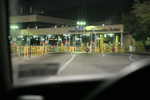
The taxi drops us at Rosario’s sister’s home, where the trusty Nissan Frontier waits. We transfer luggage to the truck and head like zombies for the Otay crossing. When we arrive at 1:30 a.m., there are only two short, thin lines. “Mira, it’s not so bad,” I say to a reclined Rosario. I undo my seatbelt and make myself comfortable for what should take 30 to 40 minutes. At this hour, the customs agents typically work slower than normal, but after 45 minutes and only advancing 10 cars, I start having my doubts. Cars continue to gather in other rows, to the point that I no longer have an exit option. After asking a passing window washer, and seeing cars turn and head back, my half-conscious mind realizes the lanes are closed. No one is getting through.
I see a brief opening between cars and shove my way into the outside lane, making an overdue escape. Too tired to be outwardly angry, I take my grumpiness to San Ysidro to give it another shot. Otay is supposed to be open 24 hours, but because it’s a secondary entry point, it can be less consistent. We arrive at San Ysidro to much longer lines full of sleeping cars, lights and engines off. “Let’s just go to a hotel to sleep,” Rosario offers. But I’m not in the mood. I want to sleep in my bed tonight even if it’s just for a few hours. “Let’s just sleep in the SENTRI lane. It opens in a couple hours,” I decide.
It’s now 3 a.m. as we pull alongside one other car already waiting in the lane. I put it in park, turn off the engine, and pull out the laptop to play solitaire. I hit a second wind, now unable to sleep. After a half-hour losing repeatedly at the Vegas-style three-card game, I take out the camera.

At 4 a.m., the lane opens and we cross the line. The final leg of the drowsy marathon came to a close another half-hour later, and sleep came soon thereafter. As a privileged member of the SENTRI program, my heart goes out to all of my compas who were already beginning their workweek as I recoup a few hours sleep under the high thread-count sheets and synthetic down comforter of my king-sized bed.
Academically, that is, not physically. Peter Skerry, political science professor at Boston College, studies social policy, racial and ethnic politics, and immigration. In the current edition of Foreign Policy magazine, he writes:
[ The border ] is a jerry-rigged example of American ingenuity that reflects not merely ambivalence about immigration but also the competing objectives and compromises characteristic of America’s decentralized and fragmented political system. Moreover, immigration control alone was never the driving force behind the building of the barriers. Instead, border-control policies have had to piggyback on other overriding national concerns. The result is a fence that is neither as draconian and militarized as critics claim, nor as effective as supporters would like. How Not to Build a Fence, Peter Skerry
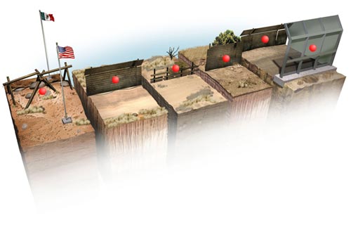
In the article, Skerry compares the U.S. México border to other militarized borders, such as the former Berlin Wall and Israel’s West Bank. Up against extreme examples, this border appears rather meek. He comments on each section of the fence to detail how its design attempts to be as friendly as possible – no razor wire, short wall to avoid injuries, easy-to-climb horizontal ribbing.
While Skerry’s comparisons are convincing at first glance, they are subtly manipulative. If the U.S and México were actually at war, the fence does appear weak. But in the context of peace, the fence still stands out as a military division. He makes reference to border conflict between Spain and Morocco, but the most recent Spanish-occupied region ceded back to Morocco was in 1969, a much more active land dispute. He goes on to minimize the desert deaths by referring to them as “hundreds” rather than thousands, attributing it to “heat and exposure, not because of a fence that maims and kills.” While technically the fence isn’t attacking people, its existence redirects crossers into dangerous areas. A well-reasoned attempt at objectivity, but it seems Skerry is stretching to put perfume and makeup on a very ugly wall.
Unfortunately, you have to create a free login membership to read the article. The illustration has rollover commentary on each of the red dots. I think it’s worth 30 seconds and the extra clicks. You be the judge.