Categories
download travel video

Palenque

For anyone who might visit, we stayed at a hoste/hotel called Maya Bell. It’s actually inside the National Park of Palenque. We had a great time exploring and soaking in the ancient city.

Some of my best photos from the trip were shot here in Palenque.

Video recorded September 20, 2007

Categories
culture crit download travel video

San Juan Chamula

While shooting in the town square, a tour guide approached and told me I should put the camera away. He said the police would take my camera and throw me in jail. At first, I thought he was just trying to get me to pay to join his tour.

The town enjoys unique autonomous status within Mexico. No outside police or military are allowed in the village. Chamulas have their own police force. – Wikipedia

A few minutes later, I was eating a bowl of chicken soup at a streetside restaurant. The texture of the chicken was unlike any I'd ever eaten. It was more chewy, almost spongy. After a few bites, I realized this chicken leg was previously attached to one of the many running freely nearby. It wasn't the couped-up, hormone-filled, force-fed flavor I was used to. The visceral experience gave me a sudden respect for my surroundings and I didnt take the camera out of the bag again.

View more photos of San Juan Chamula.

Video recorded September 19, 2007

Categories
download travel video

Cañon del Sumidero & Lagunas de Montebello

Chiapas is beautiful. We visited Sumidero Canyon, las Cascadas el Chiflón, las Lagunas de Montebello, and more.

(on technical note, I've started using iMovie'08 instead of Final Cut Pro for these videos. I still haven't finished editing our summer vacation from 2006 in FCP. I'm hoping the simplicity of iMovie (limited options) continues to speed up the process and get through all this tape…)

Video recorded September 16, 2007

Categories
download travel video

El Grito Desde Tuxtla Gutiérrez

On the first night of our trip to Chiapas, we found ourselves in the central plaza of Tuxtla Gutiérrez, Septemeber 15, 2007.

I didn't see any other tourists that night; I stuck out like a sore thumb. I ate an overpriced carne adobada steak with a plastic fork and butterknife, on a plastic plate, over a plastic tableclothed plastic table. Needless to say, it wasn't easy to eat and I spilled most of my drink from the wobbly cutting.

This was the first real "grito" I've witnessed, besides the televised version of the president in Mexico City. Here, the governer of Chiapas does the honors. Rosario says it was the weakest grito she'd ever seen.

At least there were fireworks…

Categories
download news radio web

2:45 a.m. Interview on KPBS

I’ve been working from about 5 p.m. to 3 a.m. the last few nights to keep KPBS.org updated. Our web team, along with the news staff and other volunteers, are taking turns to keep everything up and running 24/7. As I was finishing up early this morning, Doug Myrland (KPBS general manager who was working overnight on-air), asked me a few questions about the Google map to give people a sense of how we’re doing it.

Here’s the conversation:

[display_podcast]

(It’s not exactly an award-winning performance by yours truly, but I thought it was worth a posting for posterity’s sake.)

Much has progressed since this recording. Google has joined the effort to streamline updates, and those who have been updating the county maps will now be contributing directly to our Google map. In addition, a site from Governor Schwarzenegger, calfires.com, has embedded the map directly. Local CBS is linking to the map. Wired bloggers Michael Calore and Kevin Poulsen reported on KPBS’ use of Twitter and Google maps.

(Special props to Joe Spurr for pushing the use of Twitter and Google maps.)

Categories
news photo web

San Diego Fire Updates

KPBS’ broadcast tower at Mount San Miguel (along with several other towers) has burned in the fire. They’re now broadcasting from FM 94.9, streaming online from both kpbs.org and fm949sd.com, as well as through cable television.

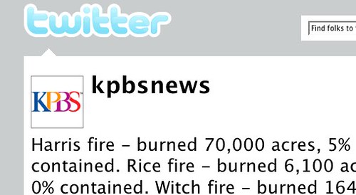
KPBS News is using Twitter to post up-to-the-minute information as it comes in:

Live San Diego Fire Updates on Twitter

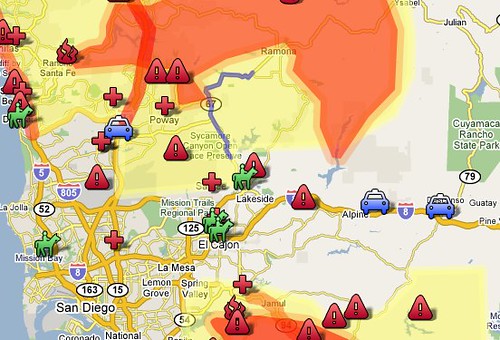
Check out this Google map for fire perimeter, evacuation shelters and residential evacuations:

San Diego Fire Perimeter, Evacuation Shelters, Residential Evacuations

My family in Escondido was evacuated but, thankfully, their homes are fine. Here are some of my brother’s pics:

Taken on the evening of 10/21/07. We were forced to evacuate the next morning. Escondido, CA. — Smokey Sunset, originally uploaded by prgibbs.

About 3:30AM looking southeast from Old San Pasqual. This is a very short distance from our house. Escondido, CA. — Fire!, originally uploaded by prgibbs.

An easterly view of our home just prior to our evactuation at approximately 6:30AM on 10/22/07. Escondido, CA. — Evacuation #1, originally uploaded by prgibbs.

About 7:30AM on 10/22/07 looking south on Orange Ave., Escondido, CA. — Orange Ave., originally uploaded by prgibbs.

About 8:30AM on 10/22/07. Looking southeast from my parent’s yard. This is a full color photo, not sepia. Escondido, CA. — Smokey Sky, originally uploaded by prgibbs.

Shortly after 9:00AM, we received another evacation notice. Me posing before we hit the road…again. Escondido, CA. — Evactuation #2, originally uploaded by prgibbs.