Google used KPBS as a case study for the Google Map we created during the San Diego wildfires in October 2007. They stopped by the studios to interview some of us who worked on KPBS’ fire map.
Tag: Google Maps
I’ve been working from about 5 p.m. to 3 a.m. the last few nights to keep KPBS.org updated. Our web team, along with the news staff and other volunteers, are taking turns to keep everything up and running 24/7. As I was finishing up early this morning, Doug Myrland (KPBS general manager who was working overnight on-air), asked me a few questions about the Google map to give people a sense of how we’re doing it.
Here’s the conversation:
[display_podcast]
(It’s not exactly an award-winning performance by yours truly, but I thought it was worth a posting for posterity’s sake.)
Much has progressed since this recording. Google has joined the effort to streamline updates, and those who have been updating the county maps will now be contributing directly to our Google map. In addition, a site from Governor Schwarzenegger, calfires.com, has embedded the map directly. Local CBS is linking to the map. Wired bloggers Michael Calore and Kevin Poulsen reported on KPBS’ use of Twitter and Google maps.
(Special props to Joe Spurr for pushing the use of Twitter and Google maps.)
KPBS’ broadcast tower at Mount San Miguel (along with several other towers) has burned in the fire. They’re now broadcasting from FM 94.9, streaming online from both kpbs.org and fm949sd.com, as well as through cable television.
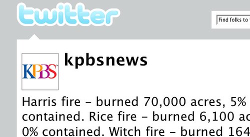
KPBS News is using Twitter to post up-to-the-minute information as it comes in:
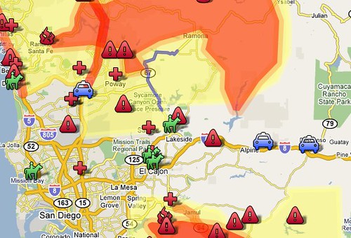
Check out this Google map for fire perimeter, evacuation shelters and residential evacuations:
My family in Escondido was evacuated but, thankfully, their homes are fine. Here are some of my brother’s pics:

Taken on the evening of 10/21/07. We were forced to evacuate the next morning. Escondido, CA. — Smokey Sunset, originally uploaded by prgibbs.

About 3:30AM looking southeast from Old San Pasqual. This is a very short distance from our house. Escondido, CA. — Fire!, originally uploaded by prgibbs.

An easterly view of our home just prior to our evactuation at approximately 6:30AM on 10/22/07. Escondido, CA. — Evacuation #1, originally uploaded by prgibbs.

About 7:30AM on 10/22/07 looking south on Orange Ave., Escondido, CA. — Orange Ave., originally uploaded by prgibbs.

About 8:30AM on 10/22/07. Looking southeast from my parent’s yard. This is a full color photo, not sepia. Escondido, CA. — Smokey Sky, originally uploaded by prgibbs.

Shortly after 9:00AM, we received another evacation notice. Me posing before we hit the road…again. Escondido, CA. — Evactuation #2, originally uploaded by prgibbs.